You can select objects, including blocks and their attributes and drawing property information, from which to extract data.
After you have selected the drawings from which to extract data, the next step is to specify which objects and their properties to extract. This is the data that is output to a table or to an external file. By default, objects are extracted from both model space and paper space, including objects in blocks and xrefs. Using the Data Extraction - Additional Settings dialog box, you can change the default settings.
The Select Objects page in the wizard displays a list of objects. From this page, you can use filters to sort by object type (block or non-block). You can narrow the list of objects even more. For example, you can display only those blocks that have attributes.
Objects and their properties are always extracted using the world coordinate system (WCS), regardless if a user coordinate system (UCS) is current when the data extraction is performed.
Select Object Properties to Be Extracted
After you have selected the objects, the next step is to specify which properties to extract.
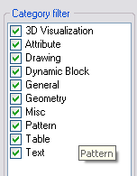
The Select Properties page in the Data Extraction wizard displays a list of properties in columns from the selected objects from the Select Objects page. This is where you make a final selection of the properties from which data will be extracted and output to a columnar format. Using predefined category filters such as general, geometry, or attribute, you can narrow the property list.
Property Categories for Filtering a Data Extraction
Extracted properties are categorized for easier filtering. For example, if you wanted to see only those properties pertaining to geometry, select the Geometry filter on the Select Properties page.

The following is a list of the filter categories for the extracted properties displayed on the Select Properties page. The categories include
After the property data is extracted, the default property names are used as the column labels in the data grid (example: Width, Length, Area, and so on). You can change these property names so that column labels are replaced with a name you specify. For example, if you extracted the length property of lines, but the column label needs to indicate the data refers to distance, you can change Length to Distance on the Display Name column on the Select Properties page.

The display name for the length property for polylines is renamed Distance.
Property Data and Unit Settings
If you select multiple drawings as the data source, and the unit setting is not the same in all the drawings, a message displays that there is a mismatch of drawing units. In this situation, the current drawing's unit settings are used for converting the numerical value of properties.
For example, if the current drawing’s unit setting is set to inches, and another drawing’s unit setting is set to millimeters, the extracted numerical data is automatically converted to inches. This happens even if the current drawing is not included in the data source.
Each property value is treated as either text or numerical data. For example, properties such as radius or length, are treated as numerical data. Attribute numerical values are treated as text. This is important to consider when using formula columns to perform arithmetic functions on extracted data.
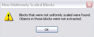
Objects in blocks that were not scaled uniformly cannot be extracted because the numerical values may not be correct or useful. For example, if a circle is in a block that was inserted with a non-uniform scale factor, the object is no longer a true circle.
A dialog box will display during the extraction that indicates blocks were found that were not uniformly scaled, and the objects within those blocks are not included in the extraction.

The property data for annotative objects is extracted using the current annotation scale setting.